Friday, October 30, 2009

The Best Fall Road Trip Destinations

fall foliage
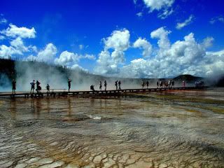
Fall is one of the best times of year to take a road trip. While some areas will have colder temperatures and even snow, the crowds are less, the temperature is perfect for walking, and the foliage lights up the hillsides, mountains, small towns, and big cities alike. However, not all fall road trip destinations are created equal! Some destinations are harder to get to in the later fall months because of snow, like Yellowstone and Yosemite. Here, we'll list five of the best fall road trip destinations you should consider taking a road trip to this fall season, for their accessibility, brilliant foliage, or lack of huge crowds!

Key West Sunset1. Key West. When the going gets tough, head the furthest south you possibly can in the United States to the beautiful Florida Keys! Key West is the final Key in this island chain, boasting an average temperature of 77-88F during the fall! It also has some of the best bars you'll ever visit, period.

2. New England. Sure, it's typical of fall, and it can sometimes be crowded when leaf peepers crowd the skinny backroads of New Hampshire, Vermont, Maine, and Mass, but there's beautiful foliage to see in other spots in New England, like Western Massachusetts, the Connecticut Valley, and along the shores of Rhode Island. Enjoy the less busy weekends along the coast, while experiencing the fall foliage of the Granite State (that's New Hampshire) and the Green Mountains on the weekdays. You'll miss the crowds, and enjoy cheaper rates.

3. Zion National Park. Zion experiences a beautiful burst of color during the early fall season. Yellow birch trees and beautiful fir trees provide outstanding contrast against the flowing, cool waters of the Virgin River, and majestic mountains surrounding the river. Head here before the end of October, when chances of snow start to increase, and the temperatures really start to plummet! You might think Utah is a state that stays warm for much of the year, but the roads can be very difficult to navigate during the cold weather months as snow blankets the highways of high elevation towns and cities.

fall central park4. New York City. I can't think of a better time of year to head to the Big Apple than autumn. In the summer, traveling around the city can be unbearable. In the fall, the air seems cleaner, cooler, and much more enjoyable for a walk through Central Park or in Times Square. You'll also see less crowds (until after Thanksgiving), and less waits. Not much of a city driver? Manhattan is just a train ride away from many cities in Connecticut, New Jersey, and Upstate New York.

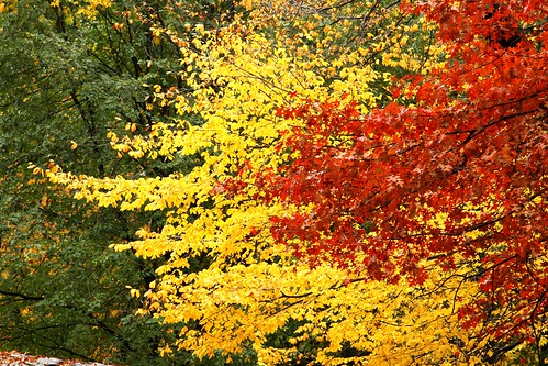
5. Great Smoky Mountains National Park. Tennessee and North Carolina both have bragging rights to the South's sublime scenery of the Smoky Mountains. Greens flip to yellows, then transition to oranges and reds throughout the elevations, as a mist creeps up the mountainsides, providing some of the most dramatic scenery you'll ever experience. For a real treat, drive the length of the Blue Ridge Parkway. This tremendous road drives through two National Parks, and traverses 469 miles of America's favorite natural scenery.

Wednesday, June 17, 2009

Boston to California Road Trip

boston to california road trip
Left: Leonard P. Zakim Bunker Hill Bridge, Boston
Photographic Print

Boston to California, are you nuts? Driving from Mass to California will take roughly five days of continuous 8 hour driving per day, but more comfortably, will take about a week. If you live in Massachusetts or California, you're in luck, because you're in the perfect area to drive to via road trip. You'll get to see the best the country has to offer and you can switch up your driving route on the way back to see a whole new set of destinations.

So what will you see along this route?

Starting in Boston, you'll see the Berkshires of Massachusetts along I-90, the upstate part of New York, which is close to the Hudson River Valley, the cities of Buffalo, Rochester, and Niagara Falls, and you'll have the option to either drive through Canada above Lake Ontario or south of it. Go south and you'll drive through the Cleveland, Ohio, and right underneath Michigan into Indiana (be sure to stop at the Indiana Sand Dunes!). This should take two days, or more if you're planning on spending some time in any of the local areas (which you should).

Further west, you'll drive through the city of Chicago and into the heartland. This is where the trip might get a little bit boring. From a few miles outside of Chicago to South Dakota and Nebraska, you'll drive through endless corn fields and farmlands. My suggestion would be to make these long driving days if you can handle it, since there's not much to do around (sorry Nebraska and Iowa) these areas.

After much driving, you'll approach a recognizable crinkle in the earth. The land will start to slope upwards as you head up I-90 towards the Badlands area of the United States. The Badlands is kind of like a dividing line between the grassy, flat farmlands and the wide open, dusty, hilly, yet interesting terrain of the west. Progressively the landscape gets more mountainous as you head further west. Consider it a foreshadowing of the western scenery to come.

Further to the west in South Dakota lies Mount Rushmore, along with the Black Hills region. This area is very close to the Wyoming border, and again the elevation starts to rise up from the flat lands to the east. As you cross over to Wyoming, you'll be near the famous Devil's Tower National Monument. This monument you would recognize from Close Encounter's of the Third Kind. It's slightly off the main path, but worth the drive out. The famous biker rally, Sturgis, is also nearby.

Grand Teton with Barn
Art Print

Head west again and you'll find Yellowstone National Park and Grand Teton National Park. These two parks are amongst the best in the United States, known for their geysers, amazing mountain scenery, bison herds, and spectacular landscape of the Grand Canyon of the Yellowstone. If you're staying in the area, Jackson Hole is a nice town to spend a few days and enjoy the scenery. It's also central to many of the attractions nearby.

You're getting close to California at this point, but you've still got a few more states to pass through. Heading southwest, you'll pass through Utah. This state is a road trip in itself, so you'll have to decide whether you have more time to spend in this incredible state.

Last stop before California: Nevada. Don't let the state fool you, it's one of the biggest in the country and can take a sizable amount of time to travel through. On the north side of the state, you'll find Lake Tahoe and Reno, to the south, Death Valley, Las Vegas, and Great Basin National Park. Like Utah, there's a lot to see in this state, but they are very spread out. Plan accordingly!

Finally, last stop, California. California is an easy vacation, with vineyards, sandy beaches, rocky cliffs, beautiful National Parks, desert cities, Disneyland, Hollywood, the list goes on and on. The best approach to seeing the most in California is to break it down into two mini road trips. Start in the northern section and pinpoint what you'd like to see. Make a circular tour arcing back towards the coast, and travel south. In the southern portion of the state, also take the arc approach. Once you pass below Santa Barbara, you can plan to head southeast towards Palm Springs, then back to the southwest towards San Diego, and back north to Los Angeles. Then, if you have time, you can take the southern road trip route home to see a whole new set of destinations.

Tuesday, June 16, 2009

Head to Utah and Experience A Drive Like No Other

Utah the Unique
Right: Utah the Unique
Art Print


Utah was made for driving and road trips. It's backcountry like no other, with unparalleled views of canyons, rivers, overlooks, mountains, Bighorn Sheep, winding roads, sandstone arches, hoodoos, eagles, coyotes, archaeology and small towns. A road trip to Utah is also the best way to see the state.

If you're flying in, you're probably going to be headed into Salt Lake City, the largest city in the state. The city is set against the backdrop of some beautiful mountains, nestled into a valley, with dry salt beds and the Great Salt Lake to the west.

Rock Formations on a Landscape, Capitol Reef National Park, Utah, USA
Photographic Print


Utah also has some of the best National Parks to choose from in the entire country, like Canyonlands, Capitol Reef, Bryce, Zion and Arches. These five National Parks are all located in the southern portion of the state, and can be driven to within just a few hours drive between each destination.

The best time to visit? Spring and fall are less crowded, and less hot. Summer temperatures are nearly unbearable for many visitors, with 100 degree temps a regular occurrence. Visit in Fall for incredible foliage, and spring for gushing rivers and snow capped mountains.

Also nearby, you may want to check out the Grand Circle region, which Utah is a part of.

Wednesday, June 3, 2009

Plan out your Road Trip Across the USA

Jumbo rocks at Joshua Tree National Park, California, USAIt's warm, you have some vacation time to use up, and the open road begs to be explored. It's the perfect road trip season, and there are millions of destinations awaiting you all across America. Picking places to go is the easy part. So how do you plan all this out?

First, you'll want to map it out. Head over to Google Maps or Mapquest (I prefer Google Maps because their directions seem more accurate and they have a street by street view in many neighborhoods). Punch in all of your destinations and see what makes sense. Click "add destination" after your first search to add more places. When you're done, you'll have a map that pinpoints all of your arrival points, along with the time. I keep the rule of thumb that more than a few hours on the road and you'll get bored, and won't really experience what the area has to offer. If you can, space out your destinations so there's only a few hours at most driving between destinations.

Next, you'll want to visit the How to Plan a Road Trip guide page. This will give you some excellent tips on packing, where to stay (so you can get in and out quickly!), and how to pick destinations. You'll also find out how you can save some cash on the road.

Before you leave on your road trip, you'll also want to go through your own checklist of things to do. Preparing for vacation, especially the long ones, will give you a good peace of mind so you can actually sit back and relax while you're on the road (and have less to do when you get back).

To plan out individual sections of your trip, check out these trip planners below:
Florida road trip
East Coast Road Trip
California Road Trip

Thursday, May 14, 2009

The Grand Circle of the Southwest United States: The Ultimate Road Trip Experience

Visiting the southwest of the United States via road trip paints a picture of the region's multicultural background, with a mix of American, Spanish, and Native American influence and heritage. For thousands of years, the Puebloan people inhabited the area of the Colorado Plateau and the Sonoran desert. A large number of unique National Parks can also be found in this region of the country, like the famous Grand Canyon, Bryce Canyon, Zion National Park, and Arches National Park.

Monument Valley - Arizona
Monument Valley, Arizona


A road trip to the Grand Circle (a nickname for this grouping of National Parks and sites) will take approximately 10 days, or longer for those that like to get out and experience everything this land has to offer. From the wide open desert expanses of Northern Arizona to the stunning Grand Canyon, you'll come across ancient Indian ruins, prehistoric rock strata in the canyons, and gorgeous, awe inspiring panoramic views of the southwest.

Sunrise, Grand Canyon
Sunrise at the Grand Canyon


To the north, you'll gaze upon the unique hoodoos formations of Bryce Canyon National Park and Cedar Breaks National Monument of Utah. Over long periods of time, erosion from water and wind have carved towering red and white rock spires out of the sandstone that remains. Zion National Park gives a challenge to hikers in the steep, dark canyons of the Virgin River known as the Narrows. Close in proximity to Bryce, this area of Utah is a favorite for travelers across the world.

Amphitheatre of Bryce Canyon National Park at Bryce Canyon
Bryce Canyon in Utah


Further east, the area of Capitol Reef National Park splits the state of Utah in two, with its giant crinkle in the earth's crust known as Waterpocket Fold. Heading east still, the destinations of Arches National Park and Canyonlands National Park await. This area of southeast Utah is centralized by the desert town of Moab, a hub for rock climbers, mountain bikers, hikers and photographers alike. The incredible views of the sandstone arches, wide canyons carved by the Colorado, and the unique desert wildlife make for an unforgettable experience and road trip.

When driving through this region, it's important to know the daytime temperatures crest near 100 degrees F during the summer. This means it will best to hike the parks during the morning and late afternoon to avoid the blistering heat. Parks can also get crowded during summer, so if possible, plan your visit before the summer or in the early autumn months.

Arcing slightly east, you'll drive to Black Canyon of the Gunnison of Colorado. This deep, dark marbled canyon has steep black walls that plummet to the Gunnison River, thousands of feet below. Completing your trip, you'll head back west towards Nevada's Great Basin National Park and back towards Arizona.


View Over Canyonlands National Park
View over Canyonlands National Park


Phoenix is an ideal destination to fly into to start the trip, or Salt Lake City. These two places are close enough to most of the parks that it won't take much time to get to your first stop. Some of the cheapest deals can be found at Priceline.com, while I've found Enterprise to have some of the cheapest and most reliable rental cars. Have fun on your trip!

Wednesday, May 13, 2009

Travel to 30 of the Most Popular (and Least Appreciated) National Parks in the United States

united states flagWith hundreds of National Parks and historic sites to choose from, the National Parks system of the United States has a park close to everyone, no matter where you live in America.

In the east, you'll experience some of the country's best known and most traveled to destinations, like Acadia National Park and the top draw Great Smoky Mountain National Park. To the south, the Everglades and Dry Tortugas are big attractions, while in the midwest and Great Plains, the country shifts from rolling valleys and forests to the rocky cliffs of the Great Lakes to the scenic farmlands and desolate Badlands National Park region of South Dakota.

Yellowstone National Park


Heading further west, you'll encounter some of the grand, dramatic scenery of Yellowstone, the Grand Circle, and the majestic granite peaks of Yosemite. To the north, the icy glaciers of Washington state cover Mount Rainier and the Cascades, while the coast varies greatly with the old growth of the Redwoods and Olympic National Park.

As you can see, there are hundreds of historic sites and National Parks desitnations to cover in the United States. Each have their own unique personality, wildlife and charm to call their own. Break them down into sections and explore each area by road trip, or just do it all in one fell swoop by taking an extended road excursion.

I've highlighted 30 of some of the most popular and underrated National Parks in America here, many of which I've personally visited and loved. Don't know where to start with your National Parks journey? Pick one, any one. Choose the closest one if you're under time constraints, or if you have the time, choose one far away. Once you've been bitten by the road trip travel bug, there's no headed back!